 |
|
Canadian Historic Sites: Occasional Papers in Archaeology and History No. 19
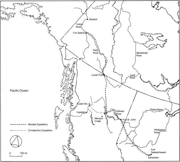
by Gordon Bennett The Military LegacyI Unlike the First World War, the impact of which was virtually negative, the post-Pearl Harbor phase of World War II engendered a massive investment in northern transport facilities that was directly related to the war effort. Of these most important, insofar as it related to the territorial transportation system, was the construction of the Alcan Military Highway. II Stripped of its strategic character, the Alcan Military Highway can be seen as the last and only successful essay in a series of attempts that spanned half a century to provide the Yukon with an overland link with the outside. As early as 1897 Commissioner Herchmer of the North-West Mounted Police, in anticipation of a deluge of Canadian gold seekers over the so-called "Back Door Route" to the Klondike, had commissioned Inspector J.D. Moodie "to collect exhaustive information on the best road to take parties going into the Yukon via [the Edmonton-Pelly] route." Moodie was instructed to identify those sections "where a wagon trail can be made without expense," to report on water crossings that would require bridges or ferries, to take note of the availability of fuel, feed and hay, and to select sites that were suitable for the construction of supply depots. With four fellow officers, an Indian guide and a Métis, Moodie left Edmonton on 4 September 1897. His supply kit was meagre, consisting solely of 100 pounds of pemmican. The expedition was ordered to live off the land and to keep the pemmican "until the last resource." Moodie was scheduled to reach the Yukon that winter, at which time, Herchmer told him, the pemmican might be the only "means of taking your party into the Klondyke."1 Both rations and schedule were soon to prove terribly unrealistic. The expedition did not reach Fort St. John until 1 November and another month elapsed before preparations for the next leg of the trip were in order. Beyond Fort St. John, Moodie encountered a series of unexpected obstacles. Winter travel made living off the land extremely difficult. A succession of unreliable guides and terrain that was arduous and largely unexplored slowed the party considerably. The trading posts upon which Moodie was dependent for provisions were habitually undersupplied with the result that the expedition was unable to replenish its stores. Caches, which advance parties had established at designated points along the route, were gone when the main party reached them, stolen by local natives or stampeders en route to the Klondike.2
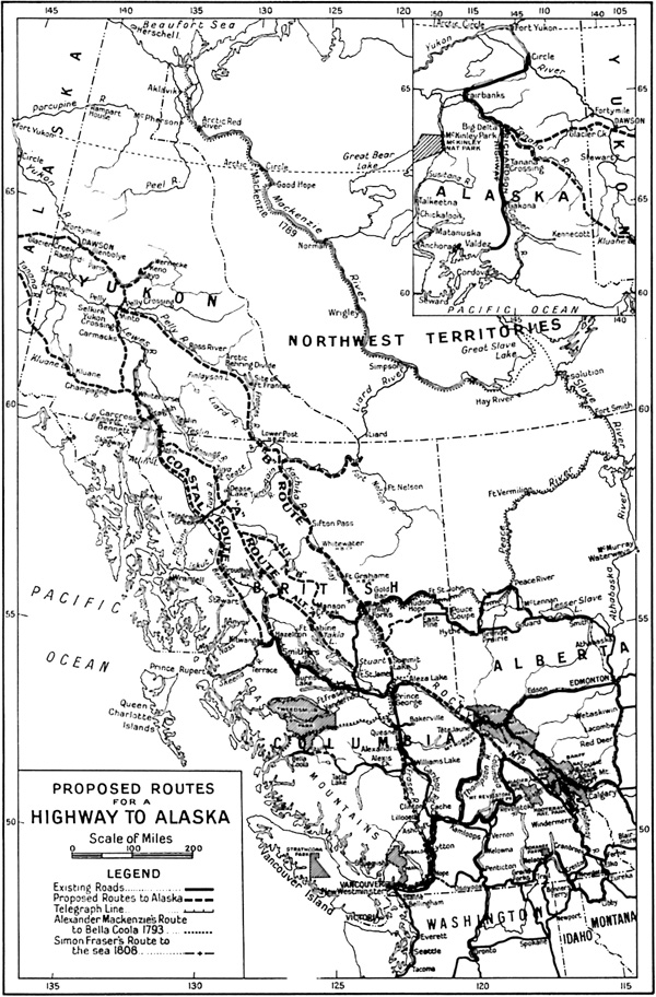
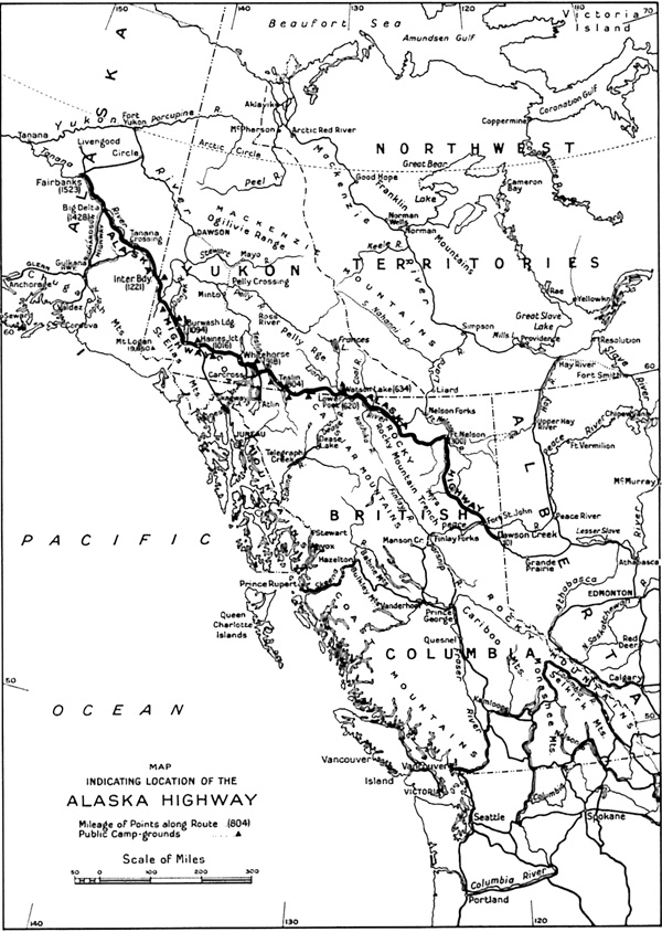
Eleven months after setting out from Fort St. John, Moodie's spent and haggard party reached Fort Selkirk. The great stampede was almost over, leaving in its wake little need for an Edmonton-Pelly road to the Yukon. In his final report to Herchmer, Moodie wrote that "with regard to the usefulness of this route to the Yukon, I should say it would never be used in the face of the quick one via Skagway and the White Pass."3 It would take 50 years and the Alaska Highway itself to vindicate Moodie's opinion. Undeterred by Moodie's conclusions and a declining Yukon economy, a second, more ambitious scheme was broached; to blaze a road between Edmonton and the territory. Once more the task of construction fell to the Mounted Police, and on 17 March 1905 Superintendent Charles Constantine, whose association with the Yukon dated back to 1894 and the halycon days of Forty Mile, set out from Fort Saskatchewan with a party of 31 for the southeastern terminus of the proposed road, Fort St. John. Constantine's instructions were to build a 750-mile-long, 8-foot-wide wagon road, to corduroy those sections located in bog and marsh, to install necessary bridging and to construct roadhouses at 30-mile intervals. With only the most primitive of tools at its disposal, the party completed 94 miles of road during its first season and added 134 more, bringing the road to a point 20 miles west of Fort Graham, by the fall of 1906. In September 1907 the detachment reached cabin number 4 on the British Columbia-Yukon telegraph line, 377 miles from the base camp at Fort St. John. Work was not resumed in 1908 because negotiations with the government of British Columbia over financing that province's portion of the road broke down and as a consequence, the road, fittingly described by later writers as the "Road to Nowhere," was abandoned.4 Twenty years were to elapse before another scheme to link the northwest corner of the continent by road was to capture popular attention. This time the initiative shifted from Canada to Alaska where a territorial engineer from Fairbanks, Donald MacDonald, mounted a vigorous campaign to unite Alaska with the mainland. Unlike previous Canadian efforts to link the Yukon with the outside, which had generated little if any public interest, MacDonald was able to enlist the support of the International Highway Association and with the slogan "Seven million dollars purchased Alaska for the United States, seven million more will make Alaska one of the United States," win wide public acceptance for the project in Alaska and Washington state and the endorsement of a number of national associations in the United States. Although the Yukon did not figure directly in the scheme, certain residents in Dawson organized a chapter of the International Highway Association as a demonstration of their own particular interest in the road. As well, the province of British Columbia, through which the major portion of the proposed road was to be located, showed a keen interest in the scheme.5 The project gained momentum when in April 1929 the Alaska legislature proposed that representatives from the United States and Canada be convened to study the question. The American initiative continued into 1930 when Congress authorized the president to appoint three "special commissioners to co-operate with representatives of the Dominion of Canada in a study regarding the construction of a highway to connect the northwestern part of the United States with British Columbia, Yukon Territory and Alaska." A Canadian commission was appointed the following year which included George Black, MP for the Yukon. In October the American commission met with its Canadian counterpart in Victoria where exploratory discussions on the technical and economic aspects of the proposed highway took place. Two years later the United States commission submitted its report to Congress. It concluded that the "highway is a feasible project and can be built at reasonable cost" and recommended that negotiations be undertaken to ascertain Canada's interest in proceeding with the scheme.6 A lack of interest on the part of the Canadian government is suggested by its failure to publish a separate report of the Canadian commission's findings. For George Black the entire experience must have been exasperating. His constituents spoke with practically one voice in support of the highway, advocating its construction as a make-work project. Except for the indomitable T. Dufferin Pattullo, who as premier of British Columbia had a vested interest in seeing the discussions bear fruit, Canadian support for the scheme was very limited.7 The general election of 1935 did not result in any immediate modification of the Canadian position. Mackenzie King's economic programme was, if anything, less ambitious than his predecessor's and the relief aspects emphasized by the highway's proponents failed to impress him. American pressure was not so easily thwarted, however, and in March 1936 the United States raised the issue again. King did not reply directly to the United States government, but submitted the highway proposal to the Department of National Defence. The department argued that the highway "would provide a strong military inducement to the United States to ignore our neutral rights in the event of war between that country and Japan" and strongly advised against Canada participating in a joint highway venture.8 Armed with the opinion of his military advisers, King travelled to Washington in March 1937 to discuss, among other things, the proposed highway. Ironically, both in prospect and retrospect, Roosevelt emphasized the highway's potential military value "in the event of trouble with Japan." King conceded, somewhat misleadingly in view of advice tendered by the Department of National Defence, that "that was a matter which could be looked into," but refused to commit himself "as to the possibility of any construction." For the moment Canadian neutrality had been successfully defended, but Roosevelt's persistence found an ally in Premier Pattullo who proved far more responsive to the needs of West-Coast defence and the Alaska highway than Ottawa. Pattullo's public pronouncements urging the American government to exert strong pressure on Ottawa greatly chagrined the prime minister who was extremely sensitive on the issue of Canadian autonomy. According to James Eayrs, Pattulo's actions had the effect of confirming the cabinet's determination "that nothing should be done." As for suggestions that the United States take full responsibility for funding the project, King replied that "grounds of public policy would not permit using the funds of a foreign Government to construct public works in Canada. It would be, as Lapointe phrased it, a matter of financial invasion, or as I termed it, financial penetration."9 In 1938 the United States chief of staff reported that "the military value of the proposed highway is so slight as to be negligible."10 Coincidentally, a Canadian interdepartmental committee submitted a report to the government which outlined a number of advantages to be gained from building the highway. These included opening up new territory for settlement; resource, tourist and recreational development; facilitation of air traffic, and unemployment relief. In the meantime, President Roosevelt, at the behest of Congress, had appointed a five-member commission to cooperate and communicate directly with any any any similar agency which may be appointed in the Dominion of Canada in a study for the survey, location, and construction of a highway to connect the Pacific Northwest part of continental United States with British Columbia and the Yukon Territories [sic] in the Dominion of Canada and the Territory of Alaska. In a seeming reversal of its previous position, the Canadian government passed an order in council on 22 December 1938 appointing a five-member commission to enquire into the engineering, economic, financial, and other aspects of the proposal to construct the said highway to Alaska and to meet for the purpose of discussion and exchange of information with the United States Commission. That the reversal was more apparent than real is suggested by the preamble to the order in council which mentioned the repeated representations from British Columbia and the United States and was worded to suggest that the decision to appoint a Canadian commission was a concession to these pressures. Nevertheless, it can be inferred that the most obnoxious features of the highway proposal, that is, those aspects which might compromise Canadian neutrality and autonomy, had been removed. In the time-worn tradition of Canadian politics, a tradition that was raised to the level of a high art by Mackenzie King, the government appointed a commission, the sole purpose of which was to study the problem. The Canadian commission held a preliminary meeting at Victoria in April 1939. This was followed by a series of public meetings, one of which was held in Whitehorse. A number of local representatives were heard, all but one registering support for the proposed highway. The sole dissenting voice was that of W.D. MacBride who read a prepared statement on behalf of Herbert Wheeler, the president of the White Pass and Yukon Route. MacBride argued that the cost of the proposed highway far exceeded any benefit that would accrue from its construction. He declared that the road would be superfluous, that the "Yukon is amply supplied with transportation facilities now." He suggested that the airplane was and would continue to be a far more effective tool in developing the territory than any highway. While MacBride expressly disavowed any conflict of interest, it is obvious that the White Pass and Yukon Route considered the proposed road to be a serious threat to its own operation. Although the company was undoubtedly sincere in questioning the validity of the scheme — there was barely enough traffic to keep its own operation going — the company's opposition must be viewed in the light of the potential impact of another access route on its balance sheets. The real issue, as identified by the inhabitants of the territory, was cheap transportation and a suspicion prevailed, the apparent economic difficulties of the White Pass and Yukon Route notwithstanding, that the company was taking advantage of its monopoly and that an alternative form of transportation would be cheaper than the service provided by the White Pass and Yukon Route. The commission's almost cursory forays into Whitehorse and Carcross marked the first and last time that an opportunity was provided for the territory to participate in the discussions. Thereafter, the commission concerned itself with the accumulation of specific data relating to possible routes, construction costs and financing. Paradoxically, in view of the highway's ultimate location, the request for a hearing from interests representing Edmonton was rejected on the grounds that the order in council creating the commission had specifically confined its consideration to routes through British Columbia. Throughout the 1930s, routes through British Columbia were the only ones to receive serious consideration in Canada and United States. The Edmonton route, which the Canadian government had actively promoted at the turn of the century, fell into disfavour, largely because the initiative for the highway during this period came from the United States. An aerial reconnaissance programme was undertaken in 1939 to investigate the three British Columbia routes then under discussion.11 Each of them originated at Prince George although in the case of the "coastal" and "A" routes, Hazelton, 300 miles northwest of Prince George, was selected as the projected point for new construction to take advantage of the existing highway between them. The western or "coastal" route, as it was designated, ran through Hazelton and followed the Skeena River west to Kitwanga. From Kitwanga the route struck north, skirting the Nass, Bell-Irving and upper Iskut rivers to Telegraph Creek. From Telegraph Creek the route followed the telegraph line through Atlin, Tagish, Carcross and Whitehorse. At Whitehorse the route followed a westerly course to Kluane Lake via Champagne and Kluane, thence northwest to the headwaters of the Tanana River, linking up with the Richardson Highway at Big Delta in Alaska. The "A" route, located east of the coastal route, followed the telegraph line out of Hazelton to the Klappan River. From the Klappan it ran north to the Stikine, followed the east bank of the Taya River to Gun Lake, crossed the Nakina and linked up with the telegraph line to Atlin. An alternate "A" route, running out of Fort St. James at Takla Lake, converged on the main route west of the upper Skeena River. The "B" or Rocky Mountain trench route originated at Prince George, followed the Parsnip River to its confluence with the Finlay at Finlay Forks, and continued along the Finlay to Sifton Pass. From Sifton Pass it ran along the west bank of the Kachika, over the divide to the Liard and Frances rivers, and down the Pelly to Pelly Crossing. From Pelly Crossing it followed the Overland Trail to Dawson, linking up with the Richardson Highway from Glacier Creek. The coastal route was found to be impractical on the basis of aerial reconnaissance. Although it furnished land access to towns along the coast and surpassed the other routes in terms of scenery — an important factor in assessing tourist potential — it failed to satisfy the conditions established for engineering feasibility and cost. River valleys were deep and passes through the mountains were correspondingly high while heavy precipitation made year-round operation questionable and portended excessive expenditures for maintenance.12 The commission recommended that field work be continued on route "A" during 1940 in order to complement the information already obtained on route "B."13 The commission submitted its final report in 1941. While the commission found that cost, engineering feasibility and tourist potential were not decisive factors, mineral potential, proximity to the Peace River agricultural belt and air routes favoured the "B" or Rocky Mountain Trench route.14 The coastal route, which had long been favoured by the United States, especially that portion following the air route into Alaska from Whitehorse, was completely bypassed by the Canadian commission's recommendations. Whitehorse, the transportation hub of the Yukon, lay some 200 miles due west of the proposed road; 13 years of American initiative had been crowned by a Canadian report which almost totally ignored the wishes of the United States. Whether the American government would have maintained its interest in the highway, given the Canadian preference for a road through the Rocky Mountain Trench, must remain a matter of conjecture for ultimately the fate of the highway proposal was not to be settled by the United States or Canada, but by Japan. III On 7 December 1941 Europe's second war of the century exploded into a global conflict. In what one American historian has described as an almost perfect application of the laws of war, Japan's attack on Pearl Harbor exposed the entire west coast of North America to enemy attack.15 The proposed highway to Alaska, which had languished through interminable bilateral discussions throughout the 1930s, assumed great urgency as Alaska's strategic importance, both for North American defence and materiel support for Russia, became manifest. The Alaska highway, which had failed of accomplishment in time of peace, became a reality in time of war. "Fear," Edward McCourt has written, "is a mighty stimulus to achievement."16 On 2 February 1942 the United States War Department ordered the immediate preparation of a survey and construction plan for a military road to Alaska. The Canadian government was informed of the plan on 13 February and approved it the same day, and on 14 February the United States government issued a directive to proceed with the project.17 A formal agreement was signed on 17 March 1942 outlining the respective obligations of the United States and Canada for implementing the plan. Under its terms the United States undertook to construct a military highway from Dawson Creek, British Columbia, to Fairbanks, Alaska, via Big Delta on the Richardson Highway. The American government agreed to maintain the highway for the duration of the war and for a period of six months following the cessation of hostilities, after which that portion of the highway situated in Canada was to become the property of Canada. For its part, the Canadian government agreed to furnish necessary rights of way and local construction materials, and to waive import duties, licence fees and income tax on American companies and citizens.18
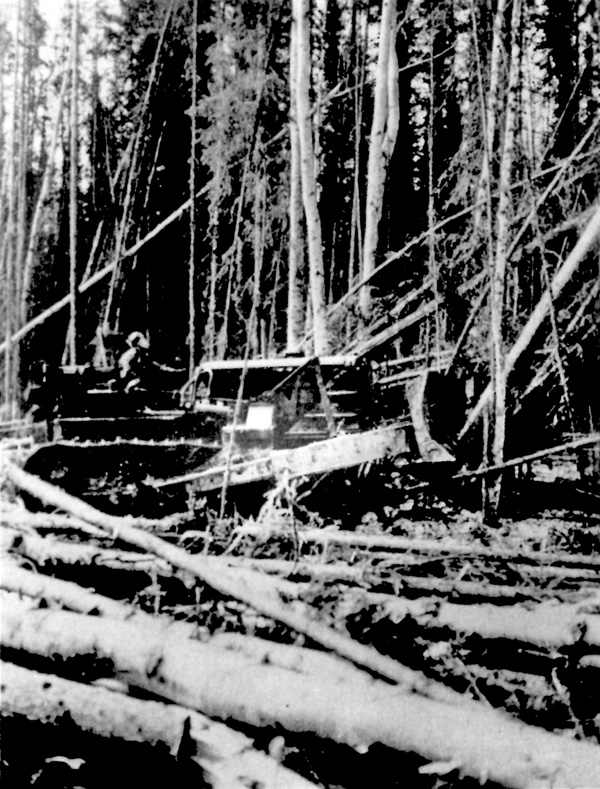
The existence of a series of airfields between Edmonton and Whitehorse proved to be a decisive factor in determining the location of the proposed highway. Known as the Northwest Staging Route, this series of airfields satisfied the strategic requirement for an inland route to secure the highway from enemy attack and had the added advantage of being tributary to Edmonton so that supplies for the highway could be moved over existing land and air routes should the West Coast ever be closed to shipping. It should not be assumed that the staging route was assigned an entirely auxiliary role, however, for the highway was intended not only to meet the "need for a year round truck route for the movement of freight to Alaska," but also to provide ground access to the staging route airports in order to facilitate the transport of supplies to Russia.19 Conceived in 1939 as a means of facilitating civilian air travel between Edmonton and Whitehorse, the Northwest Staging Route was the name given to a series of airports built at Grande Prairie, Alberta, Forts St. John and Nelson in British Columbia, and Watson Lake and Whitehorse in the Yukon. A complementary feature of the Northwest Staging Route was the construction of a number of emergency landing fields "in accordance with standard airway practice" at intermediate points along the way. Construction began in 1940 and by September 1941 the route was opened to aircraft flying by visual flight rules. All-weather flying was begun in December following the installation of radio ranges.20 While construction of the Northwest Staging Route occurred coincidentally with the first two years of the war, it was not until the United States became a belligerent that the air route's original commercial character was altered. The American declaration of war and the decision to proceed with the highway forced a reconsideration of the non-military use for which the route had been designed. Beginning in 1942 the principal airfields were enlarged, navigation facilities were augmented and hangars, workshops, refueling systems and airport lighting were added. Living accommodation was expanded and power and water services were increased. All this was done over a period of 18 months and completed in July 1943.21 Locating the highway was no easy matter since virtually no one had any firsthand knowledge of the terrain to be traversed.22 For this reason much of the actual locating of the right of way was left to the discretion of surveyors in the field.23 Where the topography of a specific region suggested that a certain airfield could best be reached by a branch road instead of the main highway, such a deviation was permited. As one observer has aptly noted, the highway "follows the line of least resistance." This was the result of a construction plan that demanded "an alignment that would ensure completion of the road as a practical military highway in the minimum possible time employing the maximum forces and equipment."24 Under a phased construction plan conceived by the War Department, the Alcan Military Highway was to be built in two stages. The first stage called for the construction of a pioneer or tote road to be built by the United States Army Corps of Engineers, the second for a finished gravel highway to be built by civilian contractors working under the authority of the United States Public Roads Administration. Original specifications called for a permanent highway with a 36-foot grade, the middle 20 feet to be surfaced with crushed rock or gravel. This was subsequently modified to a grade of 26 feet west of Fort St. John.25 Construction began in March 1942. In all about eleven thousand military personnel divided into seven regiments were assigned to the project. To expedite construction, the proposed road was divided into six sectors; Dawson Creek to Fort Nelson, Fort Nelson to Lower Post, Lower Post to Teslin, Teslin to Whitehorse, Whitehorse to the international boundary and the international boundary to Fairbanks. This enabled work to proceed simultaneously on each sector. Within each sector six construction crews were deployed, each crew building approximately 20 miles of road, then leapfrogging to the head of construction.26 Despite the variety of topographical features traversed by the highway, a basic construction technique was developed that combined the virtues of flexibility and common application. Each stage in the construction process was designed so that it proceeded in descending priority in order "to keep the lead tractors moving ahead as fast as possible." The right of way was first marked by locating parties. Advance tractors then moved in and cleared a swatch 50 to 100 feet wide. They were followed by bulldozers that levelled the right of way and did rough grading. The bulldozers were followed in turn by ditching and culvert crews and finally by finished grading crews.27
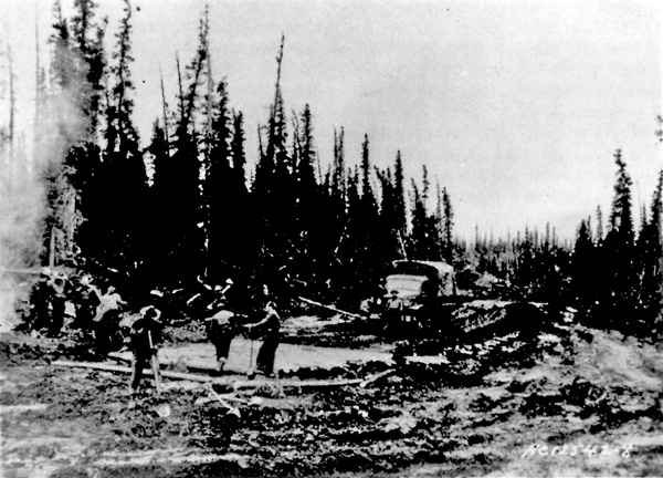
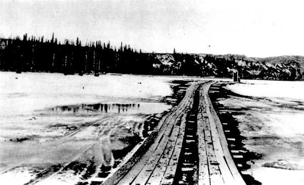
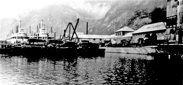
In its effort to maintain a rate of construction consistent with the urgency attached to the project, the army was constantly thwarted by river and creek crossings located on the right of way. While many such breaks in the highway system could be forded, at least for construction purposes, all required some form of bridging sooner or later since the road functioned as its own supply line. The slow pace of bridge building — bridge crews generally trailed far behind the other construction teams — was partially offset by the use of pontoons. Lashed together, floored with planking and equipped with outboard motors, the pontoons could be converted into serviceable ferries that permitted the transfer of men and equipment from one side of a river or creek to the other. With the construction of a landing slip, a portable bridge could be fashioned by connecting a series of pontoons, covering the surface with timber and anchoring each end to a deadman. The ferries could then be dismantled and sent ahead to the next crossing.28 All traffic was moved over these pontoon bridges until bridge-building teams replaced them with more permanent structures. Instead of adopting the conventional but time-consuming practice of sinking piles for supports, cribs were used. While not as permanent as the pile-type support, cribs, which were open-topped log boxes filled with rocks, could be quickly constructed. With a steel sheet cut from empty fuel drums to protect them from ice damage, the cribs were permanent enough to satisfy the highway's immediate military objective.29 Muskeg and permafrost also caused a number of delays, first because they required special treatment and second because the army dealt with permafrost during the initial stages of construction as though it were the same phenomenon as muskeg.30 Whereas muskeg removal was a necessary preliminary to the creation of a stable road surface, stripping the surface material or muck that covered permafrost had the opposite effect since it exposed a once stable subsurface to the melting action of adjacent surface temperatures and the sun. It was only after a period of trial and error and by discussing the problem with experienced local road contractors that the army adopted a method that was similar to that employed by territorial road builders during the first decade of the century. This procedure involved a minimum disturbance of permanently frozen ground, the recovering of stripped sections to inhibit melting and the adding of brush to increase insulation.31 The two-phase construction schedule established in Washington quickly broke down under the massive and constant flow of men and construction equipment over the completed portions of the pioneer road with the result that the road rapidly deteriorated.32 In retrospect it seems apparent that the planners failed to appreciate the intensive use to which the road would be put during the early stages of construction. As a consequence, the two-phase construction programme was abandoned in early August 1942 and the Public Roads Administration, which had been in Whitehorse since mid-May letting contracts to civilian road builders for the final phase of the work, was called in.33 Of the many problems associated with the building of the Alcan Military Highway, none was greater nor more persistent than supply.34 Like the gold rush of 1897-98, the Alcan project placed an enormous strain on the northern transportation system. Had conditions existed for a substantial degree of local participation in the project, much of the pressure that was brought to bear on the region's four supply routes — the Northern Alberta Railway, the White Pass and Yukon Route railway, a road from the port of Valdez, Alaska, and the Alaska Railroad — would have been relieved.35 But local participation was necessarily slight and the army and private contractors were almost entirely dependent on outside sources for manpower, material and equipment. When it is remembered that the prewar impetus for the highway had sprung from a widely held notion that those transportation facilities supplying the region were inadequate, it is hardly surprising that these same facilities, none of which had been designed for sustained, intensive use, proved to be deficient under conditions of massive demand created by Alcan. Geography and the logistics of transportation threw the principal burden of supply onto the White Pass and Yukon Route railway. The railway, with its terminus at Whitehorse, midway between Dawson Creek and Fairbanks, gave access to the highway at four points instead of two and greatly facilitated construction.36 As a consequence, the White Pass and Yukon Route railway became the project's main supply line and Whitehorse its principal distributing point. Whitehorse's de facto emergence as the operational centre of the Alcan project — an emergence that was directly attributable to the White Pass and Yukon Route railway — was given formal recognition by the establishment of the Northwest Service Command at Whitehorse on 4 September 1942. Created by general order of the United States War Department, the Northwest Service Command became the co-ordinating authority for all activities of the United States Army in Alberta, British Columbia, the Northwest Territories, the Yukon and Alaska.37
One of the first tasks undertaken by the Northwest Service Command was to increase the supply capacity of the railway. Although the White Pass and Yukon Route had made every effort to satisfy military requirements, first by running one train a day, then by hauling five hundred tons daily, the task had proved too large. When in August 1942 the army asked the company to handle two thousand tons a day, C.J. Rodgers, the president of the White Pass and Yukon Route, realized that wartime restrictions on labour and rolling stock made compliance impossible and suggested that the army assume the operation of the railway.38 This timely suggestion was accepted by the Northwest Service Command and on 1 October 1942 the railway was leased for $27,708.33 a month. The railway was subsequently assigned to the 770th Railway Operating Battalion and a large railhead was built at MacCrea, eight miles outside of Whitehorse.39 The highway was not the only defence project in the Canadian North to benefit from the increased supply capacity of the railroad. Cement for airport runways and steel girders for hangers were shipped over the railway for the Northwest Staging Route as were pipeline sections and cracking retorts for the Canol project; a massive scheme designed to tap the oil at Norman Wells in the Northwest Territories, pipe it to Whitehorse and refine it there.40 The most ambitious, if not the most expensive, of the three major defence projects undertaken in the Canadian Northwest during World War II, the Canol project was designed to supply the oil requirements of the armed forces in the Canadian North and Alaska. Begun in June 1942 under the terms of an agreement similar to the one dealing with the Alcan Military Highway and completed two years later, the project involved the laying of a four-inch crude oil pipeline between Norman Wells and Whitehorse, the construction of two ancillary pipelines from Whitehorse to Skagway and Fairbanks, the erection of an oil refinery at Whitehorse and the construction of a road running parallel to the pipeline from Norman Wells to mile 836 on the Alcan Military Highway.41 On 20 November 1942 the eastern and western sections of the Alcan Military Highway were joined at Soldiers' Summit, 151 miles northwest of Whitehorse. On 21 November the road was officially opened. Excepting a 150-mile section between Kluane Lake and the Alaska boundary which was only passable when the ground was frozen, the 1,523-mile pioneer road was completed in just over eight months and opened to through military traffic.42 Except for two troop companies that were not relieved until July 1943, all military personnel directly involved in the construction of the highway were withdrawn before the beginning of the 1943 construction season. Completing the road to final specifications subsequently proceeded under the direction of the Public Roads Administration which employed some 81 private contractors and 14,000 civilians over the following two years. At the request of the United States government, the highway was renamed the Alaska Highway on 19 July 1943.43 The Public Roads Administration was left with a task that was almost as large as the construction of the pioneer road itself. Built in haste, much of the pioneer road was substandard. Drainage was generally inadequate, many sections of the road having been poorly located or built only slightly above ground-water level. Natural insulation protecting permafrost had been disturbed. Excessive curvatures and gradients were not uncommon. The southern end of the highway was located through a noncohesive, unstable soil region known as the Bear Paw silts. As a consequence, a substantial amount of relocation and reconstruction was necessary. All the corduroy put down during 1942 was torn out and replaced, and the highway was resurfaced in its entirety. The log bridges constructed by the army were supplanted by steel structures. The Kluane Lake-Alaska boundary section was rebuilt; freight for Fairbanks being shipped downriver from Whitehorse to Circle, Alaska, for transhipment over the Steese highway to Fairbanks in 1943.44 In addition, a road was built from the all-weather port of Haines, Alaska, to Johnsons Crossing, mile 1,016 on the main highway. Maintaining the remote fifteen-hundred-mile highway was a major task. Supplies and accommodation had to be provided for maintenance crews on the more isolated sections of the road and spare parts for machinery and equipment had to be stocked for any contingency. Summer maintenance was relatively simple, consisting for the most part of grading and sprinkling the gravel surface.45 Winter maintenance, on the other hand, was more complex, especially on sections of the highway that were poorly located and susceptible to winter icing. Permafrost springs and glacial streams adjacent to the highway were particularly troublesome in this regard; the former because they "bled" during the coldest weather, forming massive ice deposits on the highway surface, the latter because they froze in such a way as to sometimes alter course and damage the highway, bridges and bridge approaches.46 Light precipitation cut snow removal to a minimum and the snow furnished an excellent road surface, superior in fact to gravel itself, but combined with extreme cold, the light precipitation permitted a high degree of frost penetration and contributed to the high cost of spring maintenance.47 IV The building of the Alaska Highway was an anomaly in the history of transportation development in the Yukon. Although more than one-third of the highway was located within its boundaries, the Yukon played no part in the decision to build the highway and only a negligible role in its construction. To be sure, a highway to the outside had long been hoped for, but the Alaska Highway can not in any way be described as the fulfillment of that aspiration. The Alaska Highway was built to satisfy a limited military objective; it was not a product of local economic conditions nor was it built to provide the Yukon with an alternative outside access route. The Yukon was incidental to its construction and as a consequence little consideration was given to what immediate, short-term impact the highway was to have on the territory. Nowhere was this more clearly demonstrated than in the wartime operation of the White Pass and Yukon Route railway. For almost two generations the railway had been the Yukon's umbilical cord; a life-sustaining artery that was as vital to the territory as mineral production itself. For this reason the decision to build the highway, while greeted with patriotic fervour by most of the local residents, was accompanied by an apprehension that the movement of territorial supplies over the railway might be adversely affected by military requirements. Unfortunately, this early apprehension was not misplaced. On 3 June 1942 George Black, MP for the Yukon, rose in the House of Commons to protest American objections "to anything being brought up by steamers on the west coast or by rail, mining machinery and even food for the inhabitants of that part of the country." In an attempt to resolve the problem, G.A. Jeckell, the territorial controller, was appointed local agent to the wartime superintendent of transportation, "with power to deal with that matter on the spot."48 While Jeckell's appointment afforded some measure of satisfaction, the situation deteriorated after the army leased the railway in October 1942. According to Jeckell, the takeover resulted in an immediate decay of local service. "Very little freight was handled" during the winter of 1942-43, Jeckell wrote, "and large quantities of perishable freight [were] not moved and allowed to freeze at Skagway." In response to local criticism, C.K. LeCapelain, a Canadian liaison officer, denied that "the civilian population of the Yukon was [being] discriminated against." While admitting that there was inexperience, incompetence and irresponsibility in the military's operation of the railway, LeCapelain wrote that the trouble really starts back in Edmonton, Prince Rupert, Vancouver and Seattle where various U.S. agencies, mostly under the control of the Divisional Engineers. . . start to pour thousands of tons more freight into Skagway than the port or railway can handle.49 The question of which should take precedence, military supply or local supply, was never resolved to the complete satisfaction of the inhabitants of the territory and perhaps it is not too trite to suggest that it could not be. The supply question did not become a crisis, however, because it was relatively short-lived. By late 1943 demand had levelled off and the army had become a great deal more efficient in operating the railway. If the building of the Alaska Highway were to be told from a Yukon perspective instead of the conventional military perspective, a much different picture would emerge. An influx of thousands of troops which more than doubled the territory's population did not occur without disruption. This theme and the corollary theme of friction between the military and local residents have been all but obscured in the literature on the highway. In its haste to complete the highway, the United States Army took little heed of Yukon sensitivities and tended to regard the feelings of many inhabitants as an obstacle to its main task. Herbert Wheeler expressed the attitude of many Yukoners when he wrote that the army "treated our people as if we were inferior beings and generally made themselves obnoxious."50 V Approximately 342 million dollars were spent on transportation and related projects in the Canadian Northwest during World War II. Of this total, a disproportionate share was spent in the Yukon, but this expenditure, massive as it was, left little more than a dubious legacy. The Canol complex, built at a cost of $133,111,000, was abandoned in 1945 although a portion of the road was later reopened. The Northwest Staging Route, designed for prewar flying conditions, was rendered in large part obsolete by the wartime advance in airplane and communications technology.51 Even the Alaska Highway, the most important of these three major projects, failed to generate the benefits so long anticipated from an alternate access route to the northwest part of the continent. The highway's impact on traditional Yukon trading patterns could not be tested during the war. Until June 1943 no commercial or civilian traffic was allowed on the facility, after which all non-military carriers were required to make application to the newly created Joint Traffic Control Board for permission to use the road. The board screened each application and issued permits only to those whom it deemed to have "legitimate" business on the highway. All other types of traffic were excluded so that military transport would not be disrupted and because of the absence of travel facilities such as service stations, restaurants and overnight accommodation. In November 1943 a scheduled bus service was established between Dawson Creek and Whitehorse under the supervision of the Joint Traffic Control Board. Until the White Pass and Yukon Route organized a highway division in October 1945, no commercial carriers operated on the Alaska Highway.52 On 1 April 1946 that portion of the Alaska Highway located on Canadian soil was ceded to Canada by the United States government in accordance with the joint agreement of 17 March 1942.53 Because of the highway's remoteness and the demand for manpower and equipment in other economic sectors during the immediate postwar period, the highway was not placed under civilian control. Instead, responsibility for its administration, improvement and maintenance was assigned to the Whitehorse based Northwest Highway System of the Canadian army.54 With the exception of pleasure travel which remained restricted until February 1948, the highway was then opened to all classes of traffic.55 The opening of the Alaska Highway was viewed in Seattle and Vancouver as a challenge to the traditional monopoly theretofore enjoyed by West-Coast ports over Yukon trade and transportation.56 In Edmonton, on the other hand, which for half a century had promoted itself as a gateway to the Yukon, the opening of the highway was greeted with great anticipation. This anticipation was short-lived. Although the highway was instrumental in bringing to an end the exclusive monopoly of Seattle, Vancouver and the White Pass and Yukon Route railway, it never attracted enough traffic to threaten their continued commercial supremacy. Several factors operated against the Alaska Highway ever becoming a major competitive force in Yukon transportation. Even as the highway was being built, the United States Army prepared contingency plans for a railroad through the Rocky Mountain Trench in recognition of the highway's inappropriateness as a transportation facility. Because the highway was conceived as a military supply route, no consideration was given to its postwar commercial potential. The highway's peacetime usefulness was also diminished because the Yukon's principal producing regions, the Dawson and Mayo districts, were bypassed. This precluded any significant degree of local traffic generation and underlined the dilemma of transforming a military supply road into a useful commercial highway. As a consultant firm concluded in 1968, "the Yukon obtained [in the Alaska Highway] a road link earlier than would otherwise have been the case but was left with . . . a tortuous road in the wrong place."57 More particularly, the failure of the Alaska Highway to attract a significant share of Yukon traffic and to mount an effective challenge against the White Pass and Yukon Route railway was attributable to the high cost of highway transport. At a minimum user-cost of ten cents per ton-mile (1948), just barely enough to ensure an adequate return to highway carriers, the Bureau of Transportation Economics reported that the highway could not compete with the railway. This shifted the burden of competition to commodity wholesale prices. Here again the highway was at a distinct disadvantage. Although Edmonton wholesale prices were slightly lower than Vancouver prices on class-rate freight shipped over the Canadian Pacific Railway from points east of Sudbury, the small amount of traffic moving on class rates — "probably not more than 15%" — was not enough to offset the high cost of highway transport or Vancouver's wholesale price advantage on other commodities.58 Like other frontier regions, the Yukon has traditionally been "next year country." Excepting the Klondike gold rush, which literally transposed "next year" into the present, the territory has always looked to the future for better times as though there were some inexorable edict of history that progress was related to the passage of time. So it was with the Alaska Highway. Its competitive limitations and burdensome maintenance and improvement costs were borne, partly because political expediency precluded following the Canol precedent and abandoning the highway, and partly because it was hoped that the highway would develop into a successful commercial artery.59 But time has not solved the problems of the Alaska Highway. Despite postwar economic expansion and the construction of the Hart Highway by the province of British Columbia, a feeder road which gives access to the Alaska Highway from Prince George via Dawson Creek, the Alaska Highway's importance as an alternative route to the Yukon has in fact diminished. A comparison of 1947 and 1964 commodity flows into and out of the Yukon shows that while total highway freight tonnage increased from 26,656 tons in 1947 to 38,932 tons in 1964, the highway's share of Yukon traffic declined sharply over the same period, from 38.1 per cent in 1947 to 22 per cent in 1964. At the same time, the White Pass and Yukon Route railway, the highway's principal competitor, increased its share from 58.5 per cent in 1947 to 76 per cent in 1964. According to the Stanford Research Institute, which prepared a report on the Alaska Highway in 1964, these figures reflect a long-term trend.60 Although the Alaska Highway has failed to meet the expectations that were anticipated of an alternate access route to the Yukon, it has played and continues to play an important role in the territorial transportation system. This is especially true in the southeastern section of the territory around Watson Lake where the highway provides a vital link to the outside supply sources and markets. However, one area of transportation where the highway has never made much of an impact and shows little indication of doing so is in the export of minerals. It is this failure which explains in large measure the significant imbalance that exists between the highway and the railroad. The highway has done much better in the movement of high-revenue commodities such as meat and produce, electrical appliances, machine parts and furniture. Petroleum constitutes another source of traffic, accounting for almost one-third of the highway's Yukon freight although here again, little petroleum moves west of Watson Lake.61 Except for local traffic use in the immediate vicinities of Whitehorse and Watson Lake, the Alaska Highway has probably made its greatest impact on tourism. Despite its gravel surface, an oppressive dust problem and frequent stretches of monotonous terrain on the heavily travelled eastern section, the highway provides a less costly form of tourist travel than air transport or the West-Coast ferry system. As a consequence, the highway is the main gateway for the thousands of tourists who visit the territory annually. Since the tourist industry is the second largest and one of the fastest growing revenue-producing industries in the Yukon, it seems clear that both tourism and the highway will play significant roles in the future.62 Full exploitation of the territory's tourist potential depends in large part, however, on eliminating the highway dust problem which makes travel not only unpleasant but potentially hazardous. A growing segment of opinion in the Yukon, alarmed at the unfavourable impression created by the highway, is agitating for an asphalt surface.63 Although a 20-mile section of the highway in the Whitehorse area has been paved, there appears to be little likelihood that the road will be paved in the forseeable future. The experience of the Alaska Road Commission indicates that maintenance costs tend to rise for paved roads instead of decreasing.64 At an estimated improvement cost of $167,651,000, paving would far exceed any possible benefit and, as the Stanford Research Institute suggested, it might well have an adverse effect on the highway's freight-carrying function through the imposition of load limits.65 For all of its shortcomings as a transportation facility, the Alaska Highway has had a major influence in shaping the course of territorial development since 1945. The rise of Whitehorse to intermediate metropolitan status, the transfer of the territorial capital and an extended economic frontier have stemmed largely from the existence of the highway. In a more direct sense, the administration and maintenance of the highway have constituted an important local industry, employing a stable labour force and bringing a welcome payroll independent of mining.66 VI The stampede of 1897-98 and the construction of the Alaska Highway, the two most significant events in the history of the territory, have invited comparison as to which was the more important. In 1965 the Department of Northern Affairs and National Resources expressed the opinion that the Alaska Highway "has probably done more to advance the development of the Yukon than any other single endeavour, including the Gold Rush." To be sure, the Alaska Highway has been an important factor in the postwar development of the territory. The publicity given the highway in popular periodicals as well as business and professional journals was instrumental in interesting many in the Yukon's resource potential and the highway itself fostered prospecting and mineral development in areas that were tributary to it. For example, the Cassiar Asbestos mines in northern British Columbia, the production from which is shipped to market through the Yukon, owe their discovery and exploitation to the highway.67 In terms of transportation, however, the White Pass and Yukon Route railway, a legacy of the Klondike gold rush, has far outstripped in importance the Alaska Highway and given the importance of transportation in territorial development, it seems obvious that the gold rush has played a greater role in advancing territorial development than the highway. The highway itself, moreover, owes its existence in part to some long-range consequences of the great stampede. The Northwest Staging Route, a decisive consideration in the decision to build the highway, would never have been conceived, let alone built, had it not been for the gold rush which attracted hundreds of people who remained in the territory after 1900. |
|||||||||||||||
|
||||||||